Nuclear Europe Maps |
||||||||||||||||||||||||||||||||||||||||||||||||||
Nuclear Accident
Risk Map |
||||||||||||||||||||||||||||||||||||||||||||||||||
|
||||||||||||||||||||||||||||||||||||||||||||||||||
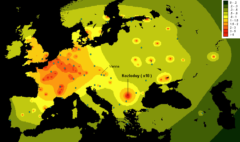
| This map has been
produced by use of a new ERL mapping software. The map projection is rectangular and represents correctly the actual NS/EW aspect ratio for the latitude of Central Greece. Mapping step: 7 km NS. NOTES ON THE MODEL 1. This map is based on the analysis of the data presented in the Atlas of Caesium Deposition in Europe After the Chernobyl Accident, published recently by the EU. A trend function D(R) has been derived from the data of the Atlas, where D is the average deposition of Cs137 as a function of the distance R from Chernobyl. More details will be presented in the Panhellenic Conference of Environmental Science and Technology (Samos, September 1999). 2. According to this simplified model, the risk in each point j equals ..... A Sumi ( Pi Wi D(Rij) ), where ..... A is a normalization parameter ..... Pi is the probability for a Chernobyl-level accident in the reactor i ..... Wi is the MWe power of the reactor i ..... Rij is the distance of the reactor i from the point j The "Chernobyl-level accident" is an accident, which results in the release of the same percentages of the core radionuclides in the environment as those from the Chernobyl 4 core during 1986. 3. The basic simplification of this model is the presumption of isotropic distribution of the deposition D. In fact, D(R) depends also on the coordinates of i and j , through the expectancy function of air transfer from i to j (some details follow below ** ). A further simplification applied in the map is the assumption of equal probabilities Pi for all the reactors, except the Kozloduy 1-4, where this probability is taken 10 times higher ( probably an over-estimation ). Therefore, the map presents simply a rough picture of the radiological risk due to severe nuclear accidents in Europe, with emphasis to the role of the Kozloduy units 1-4 in the Balkan region. ** The anisotropic distribution of D could modify considerably the picture in the simple case of one source / one target. In the case of Europe, with 88 sources ( NPPs ) and a lot of highly-populated areas, this would not change qualitatively the picture, but only the location of the most risky areas. For example, a distribution with maximum to the South direction in Central Europe would decrease the risk in Luxemburg, but increase this in Brussels. |
NOTES ON THE
RESULTS 1. The risks are normalized according to the risk for Vienna, hosting the IAEA headquarters. 2. The risk in the Greek territory lays within 0.3 - 0.7. The contribution of various NPPs in the total risk in Athens and Thessaloniki is given in the following Table.
3. Compare the above values with those for Sofia, Luxemburg and Brussels:
4. It is obvious that Kozloduy - even taken
"by 10" - contributes less to the total risk in the Greek territory than the
other European NPPs. On the other hand, the risk in certain regions of Central Europe,
populated by tens of millions, is 5 - 7 times higher than this in Athens. These
estimations support the recent remark of the Greek Foreign Minister Theodoros Pangalos,
made in Sofia: "For Greece, the nuclear safety problem is not related to
Kozloduy only, but to the safety of the nuclear power industry in general".
This is an opinion supported by our Laboratory since many years. |
|||||||||||||||||||||||||||||||||||||||||||||||||